Located on the traditional lands of the Wann clan, Sydney Olympic Park comprises 430 hectares of parklands, containing a myriad of walking tracks, wildlife habitats and historical and cultural points of interest. There is plenty to uncover along your adventure across the park, including multiple lookouts and spectacular views across the trees and over to Sydney’s CBD. These lookouts provide a perfect opportunity to pause, reflect and take a breath – or a photo!
Self guided tours
The Park is full of surprises, and now they’re all at your fingertips with our collection of self-guided tours.
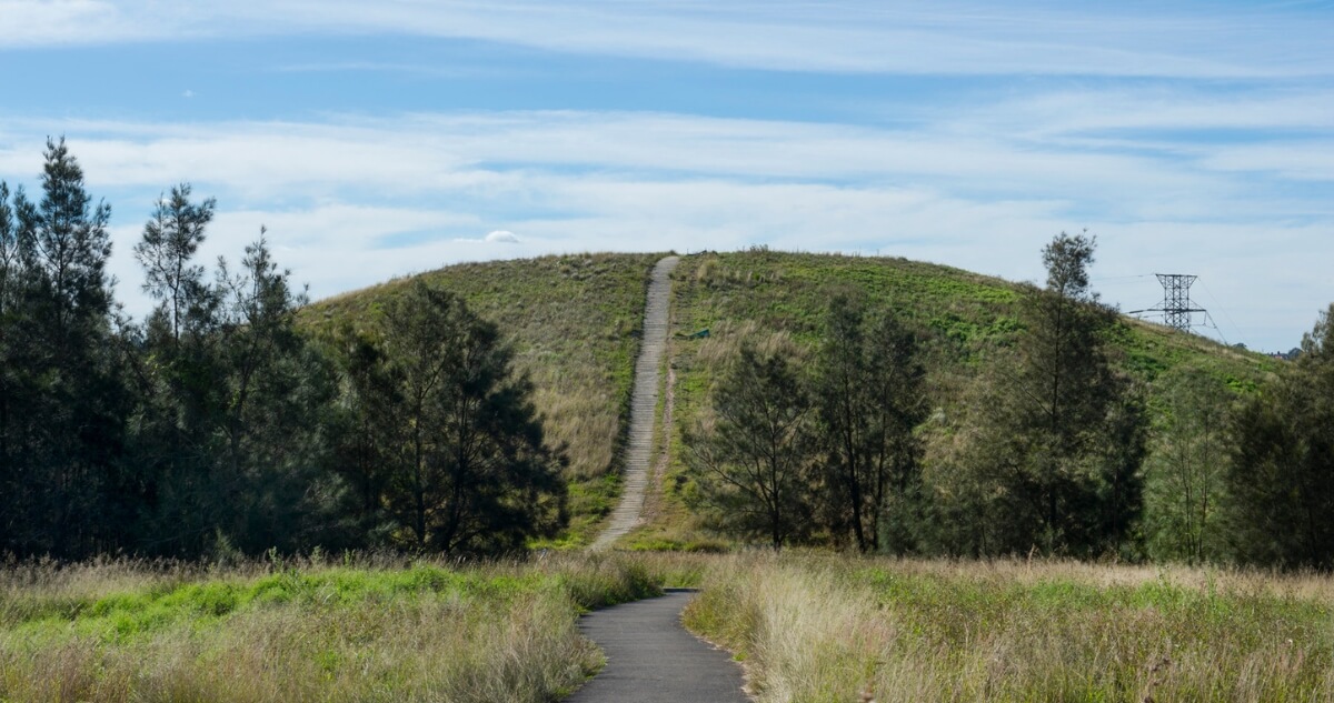
Woo-la-ra
In the native Darug language of the Wann clan, Woo-la-ra quite literally translates to ‘look-out place’. This area, now a favourite recreation place of Park residents, dominates the riverside area of Sydney Olympic Park near Wentworth Point. Perfect for hikers and bikers, Woo-la-ra offers twisting pedestrian and cycle paths that lead to a summit, providing awe-inspiring, 360-degree views of the adjacent Newington Nature Reserve, surrounding suburbs, parklands and the city skyline.
The grasslands of Woo-la-ra provide habitat for birds not found in other types of vegetation. Listen for Quails and Cisticolas that shelter and nest amongst the tall grasses – these small birds are only found in grassland habitats like Woo-la-ra.
The Markers
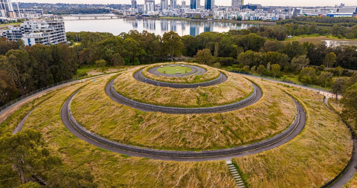
The five Sydney Olympic Park Markers are a series of conical earth mounds standing 10-20m high and cleverly constructed from materials unsuitable for re-use. Installed for the Sydney 2000 Olympic Games, the markers collectively resemble the Southern Cross from above, and serve to orient explorers within the park.
For those seeking out incredible views, these geometric forms are easily accessible on bike, wheelchair or foot, and each provides a new and stunning perspective on the Park and its visual
Bay Marker
The Bay Marker serves up a full 360-degree view of Wentworth Common and the broader Park and stadium precinct, inviting visitors to gaze out across Homebush Bay to the north. The view you’ll experience is a dramatic melding of urban landscape, the city skyline, the wetlands, rivers and beaches.
Access the Bay Marker via Bennelong Parkway near the Archery Centre.
Haslams Marker
Spiralling to a peak at the Southern end of Hill road, Haslams Marker provides a magnificent outlook across the treetops and Haslams Creek. On a sunny day, soak up the sky’s reflection off the sparkling water, and take a deep breath of fresh air as you bask in the natural, green beauty of this area.
Access Haslams Marker via Hill Road near John Ian Wing Parade.
River Marker
Top off a restful afternoon at the beautiful Blaxland Riverside Park with a walk to the top of the spiral hilltop known as the River Marker. Conveniently located alongside the Parramatta River, and close to Newington Armory Wharf, you can walk, bike or scoot to the top and take in the playground, river and park landscapes, and a view stretching kilometres across to the urban skyline.
Access the River Marker via Blaxland Riverside Park.
Silverwater Marker
The Scenic Silverwater Marker at Woo-la-ra is the perfect vantage point to take in one of Western Sydney’s iconic sunsets. Pedestrian and bike trails curl and bend to the top of the conical mound, where you can take your time inspecting the skies to try to catch a glimpse of a majestic raptor against the golden, dusky backdrop – Black-Shouldered Kites, Nankeen Kestrels and White-bellied Sea Eagles all nest and hunt in this area.
Access the Silverwater Marker via Hill Road near the Wentworth Point Community Centre and Library.
Bicentennial Marker
Positioned among the rich greenery of Bicentennial Park, the Bicentennial Marker is the pinnacle of the park’s diverse and luscious natural surroundings, taking in 40 hectares of gentle hills, mangroves and lakeside meadows. The marker offers 360-degree views of Olympic Park and the surrounding open green space, and the vast, alluring vista of Lake Belvedere. As you peer out at your resplendent surroundings, take a moment to appreciate the cultural, historical and environmental significance of this tranquil area.
Access the Bicentennial Marker from Australia Avenue at Bicentennial Park.
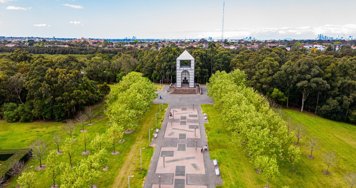
Treillage Tower
Standing as a powerful focal point of Bicentennial Park, Treillage Tower allows visitors to ascend its 3-story staircase to reach its expansive observation deck and the highest point in the park. Named in the French tradition, ‘Treillage’ refers to the latticed elements of the structure, reminiscent of those found in the gardens of 16th-century France.
From an impressive 17 metres above ground, let your eyes trace the symmetry of the park’s tree-lined pathways, dotted markers, manicured lawns and fountains, out to the city skyline, Parramatta River and beyond.
Access Treillage Tower from the centre of Bicentennial Park.
Kronos Hill and Little Kronos Hill
Alongside the dense mangroves of Haslams Creek, you will come across the slopes of Little Kronos Hill. Scattered with eucalypt trees, this natural habitat has been densified with native shrubs, planted to provide crucial habitat for declining woodland bird populations across the region.
Frog ponds can be seen at the summit and dotted around the base of the hill, connected by grassy and dispersal corridors designed to supply a safe foraging environment for the renowned and endangered Green and Golden Bell Frog.
Take a stroll to the summit and listen out for the rustling of frogs and lizards – you might even spot the Spotted Pardalote feeding high up in the tree canopy!
Zig-zag your way along the emerging path and you’ll find yourself at the top of Kronos Hill. This diverse natural habitat is home to a string of frog ponds; stepping stones between the larger wetlands of Eastern Pond and the Northern Water Feature.
Regeneration works have seen the introduction of dense shrubbery and groundcovers here as well, providing habitat for woodland birds. Bask in the song of many different native birds calling to each other across the hilltop, and spot the Musk Lorikeets feeding high up in the towering trees.
Access Kronos Hill and Little Kronos Hill from Kevin Coombs Avenue, alongside Haslams Creek.
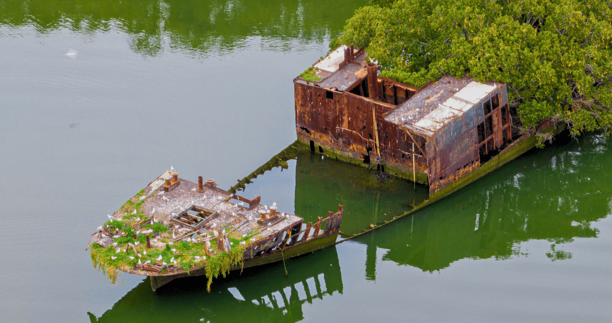
Shipwreck Viewing Platform
Ahoy! Did you know that Homebush Bay is home to a floating forest shipwreck? Not only is the SS Ayrfield steeped in history, built in Scotland and used as a transport supply boat to US troops in the Pacific during World War II, it is also covered in wild mangroves that have grown over time, decorating its hull.
The SS Ayrfield is one of seven rusted shipwrecks that are spotted across the seascape of Sydney Harbour, and is a particularly special attraction for photographers and history buffs alike. Decommissioned in 1972 and sent to Homebush Bay, the site of the former marine wrecking yards, the shipwreck has become a symbol of the industrial history of Homebush Bay and the incomparable power of nature to adapt, regenerate and overcome.
The shipwreck viewing platform is the perfect spot to take in this unique, rusted mass and its striking green growth. Visit at sunset to witness the dappled orange sunlight lighting up the deep, red rust of the ship, and marvel at this unusual beauty on the water’s edge.
Access the viewing platform from Parklands Circuit, off Bennelong Parkway at Wentworth Point.
You might also be interested in...